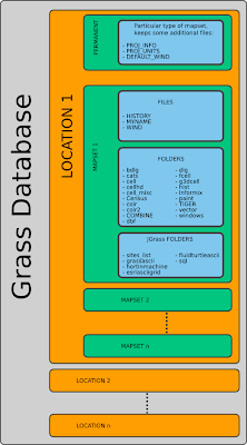
Most important files and folders for now
- WIND - contains the active processing region and the resolution
- PROJ_INFO - contains the information about the projection
- PROJ_UNITS - contains the information about projection units used
- cell, fcell - contain the raster files
- vector - contain the vector data since GRASS 6
- sites_list - contain the sites type data, deprecated from GRASS 6 on, but maintained in JGrass
File structure of GRASS Location
A GRASS raster map consists of several files in several subdirectories in a mapset, organized as follows:
- cellhd/: map header including projection code, coordinates representing the spatial extent of the raster map, number of rows and columns, resolution, and information about map compression;
- cell/, fcell/ or grid3/: generic matrix of values in a compressed, portable format which depends on the raster data type (integer, floating point or 3D grid);
- hist/: history file which contains metadata such as the data source, the command that was used to generate the raster map, or other information provided by the user;
- cats/: optional category file which contains text or numeric labels assigned to the raster map categories;
- colr/: optional color table;
- cell_misc/: optional timestamp, range of values, quantization rules (for floating point maps) and null (no-data) files;
GRASS vector maps are stored in several separate files in a single directory. While the attributes are stored in either a DBF file, a SQLite file or in an external DBMS (PostgreSQL, MySQL, ODBC), the geometric data are saved as follows:
- head: vector map ASCII header with information about the map creation (date and name), its scale and threshold;
- coor: binary geometry file which includes the coordinates of graphic elements (primitives) that define the vector feature;
- topo: binary topology file describes the spatial relationships between the map's graphic elements;
- hist: history ASCII file with complete commands that were used to create the vector map, as well as the name and date/time of the map creation;
- cidx: binary category index file which is used to link the vector object IDs to the attribute table rows;
- dbln: ASCII file which contains definition(s) of link to attribute storage in database (DBMS).
Taken from the GRASS developer's manual
No comments:
Post a Comment