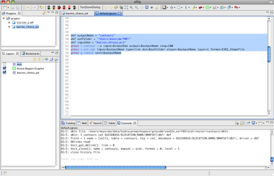
So what if I want to extract a shapefile of contour lines from a DTM?
def outputName = "contours"
def outFolder = "/Users/moovida/TMP/"
def inputDem = "bacino_chiese_pit"
grass r.contour --o input=$inputDem output=$outputName step=250
grass v.out.ogr input=$outputName type=line dsn=$outFolder olayer=$outputName layer=1 format=ESRI_Shapefile
grass g.remove vect=$outputName
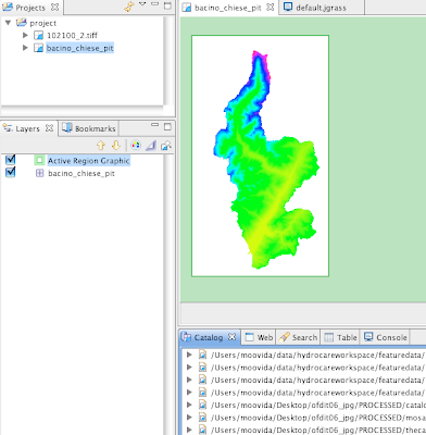
And we go from:
![](https://blogger.googleusercontent.com/img/b/R29vZ2xl/AVvXsEhSRWYfXLrlTzmhOF-zeHgRHG9YX4LX6wt_tlq00Ed1zvg2QMo2esLKQEgCKEssbfPtvYJGNwibxayGb7d6CLn3sXcDvnOHNQHE0eSpgfC5b78lZVRfWo3hz5TButQ6buLR0oH_gYqFr4g3/s400/Picture+8.png)
through:
![](https://blogger.googleusercontent.com/img/b/R29vZ2xl/AVvXsEjrO4uGdmKZBG-XvnHgplycDqyRZcYuc0JdQqIhZS6HOU23nRs0MTkgXPXpMcviQwChlIdE6RiDYKVjYpCxJBCB_Q2DVBmaKLmzpJiXOAZ1WiTm3Coz6gPPZ5EF5dhJm8TPfu6Q05G1NKle/s400/Picture+6.png)
to the needed layer:
![](https://blogger.googleusercontent.com/img/b/R29vZ2xl/AVvXsEhhNPf_Ws_xWhNNgRkyxPd5hSscg3qmsOl6W3sXMsZdo4UdzSzsL0YAat1LyevSrn9PdYZd2hTIvN6p1Aw4drtGPyQNMTHKWRpYRm5DsUVoICoNi9yOxIAnnMfx6KkZCotuUwaN7exdiC2p/s400/Picture+7.png)
No comments:
Post a Comment