Today we released SMASH 1.4.0 to the Apple and Google stores.
This release brings some bugfixes and two main features.
1) SLD support
When it comes to styling data many have expressed their hate towards the OGC standard SLD. Coming from the uDig/Geotools world, where SLD has always been used, I find it quite nice to use. Well, I use it for very simple styling, so that might be the reason behind it. Well, it seemed to be the perfect format. There are several editors and GIS that support SLD, so people will be able to create their styles for the survey. And now SMASH is one of them, even if it right now supports a subset of SLD features.
Lets' have a look. Assume to be in the region of the Resia Lake in northern Italy:
Now let's play around with some geopackage data: lake polygons, river lines and geoname points.
Sliding the polygon layer to the right allows to enter the style properties:
It is rather intuitive what needs to be done to have a lake styled. But remember to save using the floating action bottom at the bottom. This will write the style to the database table.
Et voila'. The same goes for lines:
and points. Points are the only layer types that allow labeling at the moment.
These have been very very simple styles. For those that talk SLD, these examples only had a FeatureTypeStyle and one Rule.
SMASH supports one type of theming: by unique values. In this case a FeatureTypeStyle is populated with several rules that obey to a filter that supports matching of unique values from the attributes table.
The properties page has buttons to change rules and modify them. The following is an example that features 2 FeatureTypeStyles, one with just a Rule containing a textsymbolizer:
If only one FeatureTypeStyle or Rule are present, the header titles can vary:
The result then looks like:
We decided to give also GPX files these kind of powers. If you change the style properties of a GPX layer, an SLD sidecar file is created and ensures style persistence.
Style can be defined for lines and points. If waypoints have the name tag, it can be used for labeling.
2) GPS log enhancements
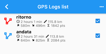
The log stats have been extended and now contain time, length, up and down delta (mind this is GPS elevation, so it is usually bad), number of points contained in the log.
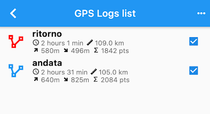
In the previous version of SMASH a Kalman filter had been added to filter GPS logs and both log types are kept in the database. It is now possible to decide to use the filtered logs in certain sections of SMASH as for example in the logs list. Just enter the GPS settings and enable the option:
If you head back to the logs list, the stats length value might be changed:
In this case the difference is around 8Km. This is due to the fact that in tunnels the GPS often goes crazy and jumps around, generating additional distance to the log. The filtered version is more realistic. But you can choose based on your usecase.
From the log list a new tool is available when sliding to the right: the Profile View
The profile view allows to analyze the profile and navigate it:
Thanks for the OwnWeb guys for this nice plugin.
Well, that is it for SMASH 1.4.0. Enjoy!


No comments:
Post a Comment