It is a while now that we have been talking about SMASH and its first testversions.
Back in this presentation at Foss4G Bucharest we were showing first results already.
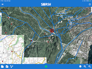
Well, now it is finally out in version 1. And here is what it looks like...
on IPad:
on IPhone
and on Android
SMASH supports a subset of features that Geopaparazzi has, but adds (apart of IOS support, which is huge) much much usability and is way userfriendly.
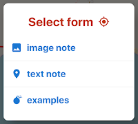
Forms are compatible with those of geopaparazzi, but also support icons:
SMASH supports various formats as for example, Geopackage (vector and tiles), MBTiles, Mapsforge, GPX and online TMS services:
Vector layers can be queried using a configurable tap radius:
SMASH also synchronizes with the Geopaparazzi Survey Server to gather project data:
and to incrementally upload work done:
SMASH finds its place on the geopaparazzi website, which has been reviewed to showcase Geopaparazzi, SMASH and the GSS. It also features a comparison table.
Back in this presentation at Foss4G Bucharest we were showing first results already.
Well, now it is finally out in version 1. And here is what it looks like...
on IPad:
on IPhone
and on Android
SMASH supports a subset of features that Geopaparazzi has, but adds (apart of IOS support, which is huge) much much usability and is way userfriendly.
Forms are compatible with those of geopaparazzi, but also support icons:
...also in the form items.
SMASH supports various formats as for example, Geopackage (vector and tiles), MBTiles, Mapsforge, GPX and online TMS services:
Vector layers can be queried using a configurable tap radius:
SMASH also synchronizes with the Geopaparazzi Survey Server to gather project data:
and to incrementally upload work done:
SMASH finds its place on the geopaparazzi website, which has been reviewed to showcase Geopaparazzi, SMASH and the GSS. It also features a comparison table.


No comments:
Post a Comment