The labels part and a raster color mask is now there for testing.
1) Example about lines labels
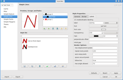
Now all the feature style panels have a labels panel added:
![](https://blogger.googleusercontent.com/img/b/R29vZ2xl/AVvXsEguSexd6RJ8nAVTeYY7UsFlzkdYMpOD7P24M0FnKSoxmk2OMiKCfNO7fRVJHckUt-8i9pjQ8RuBY9pkKNuzziuzGVEruhZpBObVY-TWDw-hWLa13MTz4NrB8LCsbFj8OYt8QcRgZOoU1O5N/s400/02_labeling.png)
from there you can do several stuff, I will just show the labelling of lines here.
More or less I tried to support everything that gepotools does (some of it is taken from the sld cookbook of the geoserver community).
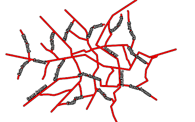
So the result would be:
![](https://blogger.googleusercontent.com/img/b/R29vZ2xl/AVvXsEg57ZamlSWEM3WgeoSfvLKi5CSPAtos5dsm6RuUEq8KWKnaFDrKAWpgFT9ANq7w-jcGDBBOUd5vhq9K9DXSYi9ymicgznoN7Y-4Gu0wq4NDaiony1Zc30l_PLd8fOTFtl687qgcth7MC7F_/s400/03_labeling.png)
2) Another thing that has been missing for a while in uDig is the possibility to create an alpha mask based on a color for imagery.
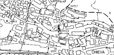
If for example I have a tecnical map:
![](https://blogger.googleusercontent.com/img/b/R29vZ2xl/AVvXsEhXCh-9hO3dWDRmQo0P4gMwQ5wJrgp3brmECdfi82PuK7wDHbqev7qRCIUORoz8vwoJ5rIsMn3uual4WsMPpgc9PuICnfOVcfACwzPyPq9jGw9O6AVpFaMYPFA_6tvEinsvL3QqIkP50W0O/s400/01_raster_colormask.png)
which I would love to see in overlay with an ortophoto, I now can go into the style options and set a color to alpha:
![](https://blogger.googleusercontent.com/img/b/R29vZ2xl/AVvXsEjOLD9o4kyjdCZ2mri5VHOKbpM3wVY8_HMx_h8djQ78nY0x6cad8RMP_dN_-PGRVdh9ldsIyXxrMN5t1kKxj3sGGo7-0UHR7MnQRQE4RgY9wGLJhmMuD7S7Vj_LfhUDstPn9CvKDxjnv34W/s400/02_raster_colormask.png)
Which then would lead to have the wanted overlay:
![](https://blogger.googleusercontent.com/img/b/R29vZ2xl/AVvXsEiNPfcNWMnUsrddzywKt48sl3gJ0ah0pHRR7UQ_IszXN7aV-ji7jQwxEjJLJc3ENM9DQ7WVxJQCL8XCfPkprx1ee07s0cyeC-cFKmBo7qaR1TwCZRp2T7NQJ5AgMS-8V_t9emDnIVf92Kk_/s400/03_raster_colormask.png)
Sadly this last is not something that is supported in the SLD specs (so they tell me), so it can't be persisted in a sld file. However it might be added to geotools as a vendor option. That would be awesome. For now, I'll enjoy it in uDig...
2 comments:
Very nice information about color ....
job government youtube
Post a Comment