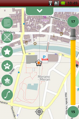
This release bring a ton of news and fixes. The two most important are for sure the fixing of some GPS issues, making the gps now faster and more stable. The other is the integration of the osmdroid project as the mapping engine for geopaparazzi. Since the mapping engine needed to get professional finally, we decided to do it properly, and the osmdroid project does that.
Another nifty addition is the support for bookmarks.

Full release notes:
New features:
* integration of the osmdroid project (brings multitouch, minimap, scalebar, enhanced rendering, multiple tile sources...)
* enhanced tools in slider over map
* support for bookmarks
Enhancements:
* enhanced handling of gps status icon
* updated documentation at: www.geopaparazzi.eu
* icons now are properly created for various densities
* possibility to delete notes and bookmarks on the visible map
* better contrast color for chart viewer
* labels properties for better overlay of poi layers
* select/unselect all on data lists
Fixes:
* fix for logs not showing up on map at logging start
* new project was landing in backed up folder
* proper distance calculation in 3d
* gpx support also for gpx 1.0, not ony 1.1
8 comments:
Would it be possible to integrate voice commands and embed picture taking via voice?
http://lists.w3.org/Archives/Public/public-xg-htmlspeech/2011Feb/att-0020/api-draft.html
I'm primarily thinking of automating biological sampling where a biologist has a bluetooth headset with a camera. Biologist catches fish, says "new fish, species, largemouth bass, length, 20 cm, weight, 600gm, take picture." The data is parsed and passed to a spatial database with geographic coordinates (postgis/postgresql) with the georeferenced photo.
Just curious..
Oh Doug, oh Doug, what did you do to me? :) To be honest I never gave a look at the speech api because I never found a usecase for it that made sense. You pushed me to have a look at it :) Well, it seems that it might be easier than immagined: http://android-developers.blogspot.com/2010/03/speech-input-api-for-android.html
even if it would require to raise the minimum android version for geopap to 2.1.
But I really like the idea to take notes by voice and parse out the text, or even trigger commands as you propose.
I'm also just curious, I'll have to try.
Andrea,
Not to complicate things too much :-), but for the instances where you are out of cell phone range ( many things biologists sample are not in urban areas), it might be best to capture the voice commands to speex, or ogg vorbis files and the images with the gps coordinates to a directory/SD card locally ( offline mode?) for delayed processing when a cellular/wireless connection is re-established?
I was trying the handcent sms application to see how it workes and in the fire of passion I had not realized that it would need (obviously) a network connection. But following your advice, how do I solve that taking picture problem? I mean, I could record when I am offline, but then I would be able to take a picture by voice command, since the audio would be parsed later... what do you think?
Good point! It may be that offline pictures would have to be manually taken. Could a warning tone be given when the cell phone loses signal? Automatically have it switch to offline mode, or should the sampling run be recorded and pictures taken manually , then have the data uploaded and processed in a burst. You could say "take picture" and the application would look for an image timestamped at the nearest the the "take picture" command was given in the audio file.
I played around with the handcent sms application to use the voice parsing feature. Well, I think the feature is not quite ready for recordings in noisy environments, since it is quite fuzzy also in non-noisy. So out in the woods that would not work that much. Also I am a bit worried about battery life, i.e. this feature (that could be switched on/off) would need internet connection to work and also the device always listening, to trigger proper actions.
I still like the idea and might make a first try to add spoken/parsed notes to the taking of geonotes.
I appreciate the effort you've taken so far! While it may not work so well in rural areas, you might be able to get it to work in urban areas with good connectivity for infrastructure inventories.
Thanks dnewcomb! Ayways yours is an interesting statement. We are using geopaparazzi more for rural area and almost not for urban environment (it has been even used in a thesis for mapping small scale wastewater treatment plants in very rural areas in Egypt, were no connectivity was available). That is also the reason why we are investing so much time in having an offline map system. I.e. because due to the mobile internet rates and the often missing connectivity, we want to be able to work with maps nevertheless. What are you thinking about? I would be glad to hear your thoughts.
Post a Comment